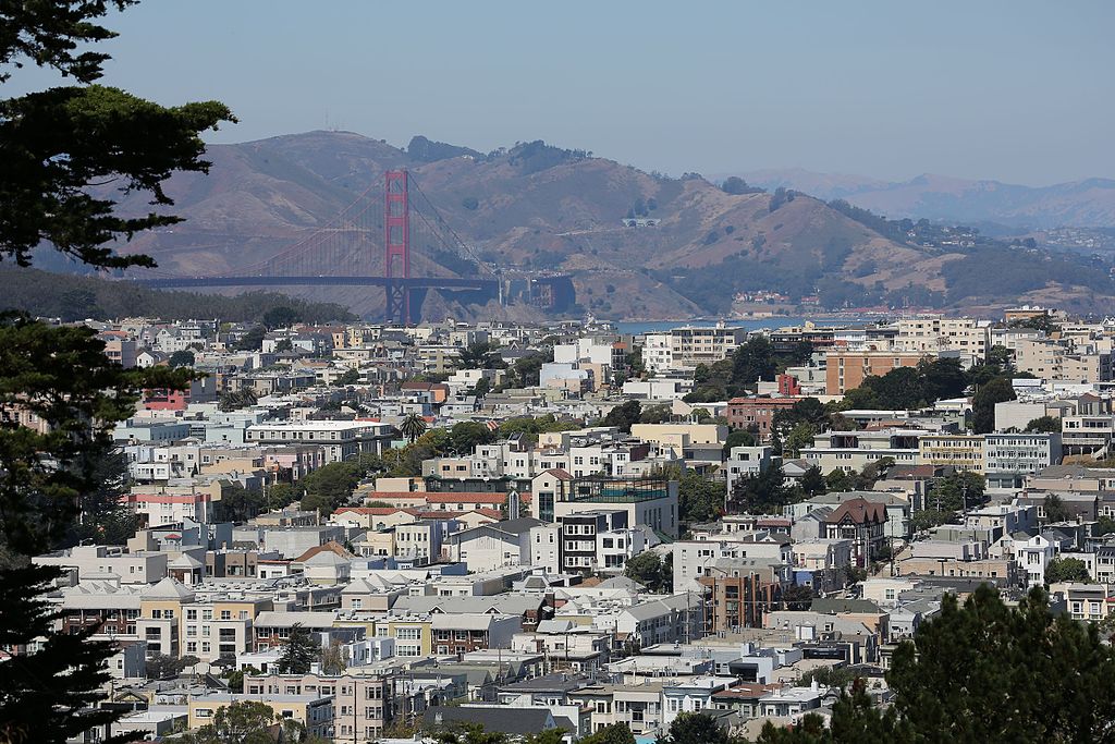
From its most urban neighborhoods to its rugged coastal trails, San Francisco is a city best seen on foot. Located on the tip of a peninsula, its small size also makes it a singularly walking-friendly city, with numerous points of interest packed into a relatively small area. Whether you’re visiting the city or have taken up residence here, one of our favorite things to do is to take one of the many city walks in San Francisco with a view.
While some of the best San Francisco walks are loops, many begin and end in different places. Public transit is usually the easiest way to negotiate the different start and end points. For downloading schedules and visitor passes visit www.sfmta.com or check out the maps located at bus shelters around San Francisco.
Polk Gulch and Russian Hill
Featuring San Francisco’s most famous street, soaring views, cobblestone alleys, cable cars, French bakeries, murals, and some fine boutiques, this San Francisco walk through a vibrant area of the city offers a tremendous variety of attractions.
DIFFICULTY: Steep
Begin at Pacific and Polk (via bus #12 or 19). Over the course of the next few blocks, you’ll pass a string of small shops and quirky restaurants.
Turn right on Union and left on Hyde–note the low hum of cable-car cables circulating under the tracks and stop at Lombard. On this classic San Francisco walk, savor the glorious views from this popular perch, watch the cable cars climb Hyde’s steep incline, and peer down Lombard Street, San Francisco’s most scenic and famous street, paved in signature pink brick and lined with abundant hydrangeas and handsome homes.
Built in 1922 with an astonishing eight switchbacks packed into one block, the street was designed to make the hilltop accessible to automobiles. Descend the crooked street and turn left on Leavenworth, then right on Chestnut. Continue down Chestnut, turn right on Jones, and head up the hill.
Past Union, turn left into Macondray Lane, a narrow, tree-lined cobblestone alley. This is the street upon which Armistead Maupin based Barbary Lane in his beloved Tales of the City series. After this momentary respite, turn left on Taylor to return to Union, where you can catch bus #41 or 45.
Buena Vista Park and Beyond
This San Francisco walk, featuring two rugged hilltop parks rising out of an elegant neighborhood, offers memorable views of the entire Bay Area and a glimpse of one of San Francisco’s most beautiful neighborhoods.
DIFFICULTY: Steep
View over San Francisco from Buena Vista Park
Start at Haight and Baker (via bus #6 or 7). Take a moment to admire the lovingly preserved Victorians on the eastern corners before heading up the staircase into the majestic hillside Buena Vista Park.
Relatively little known, San Francisco’s oldest park rewards visitors with magnificent views of the city, the bay, and the Marin Headlands filtered through a lush forest of cypress, eucalyptus, and pine trees, some of which are over 100 years old. Several paths run through this urban forest; to reach the vista point at the top, head straight up and then left along the main paved trail, continuing up through a series of switchbacks. As you spiral upward on this San Francisco walk, the views appear before your eyes.
Continue up the winding path, or take the steps to reach the grassy knoll at the top. Catch your breath and savor the soaring views (you may want to plan ahead for a picnic here).
Exit the park, following the elegant Upper Terrace to the end, where it affords a splendid view of Twin Peaks to the south. Loop to the right. Take the pedestrian walkway on the left. which boasts unobstructed views of Golden Gate Park, Lands End, and the ocean. Turn left at the bottom of the stairs onto 17th, then left again onto Roosevelt.
Stay left, veering right at Loma Vista. Corona Heights Park is ahead of you. Beyond the dog run is a rocky outcrop with a dirt footpath leading to a treeless vista point with spectacular 360-degree views over San Francisco. If you’re traveling with kids, consider visiting the Randall Museum (199 Museum Way), a children’s center tucked below the park.
Otherwise, continue along Roosevelt and turn left on Park Hill, then right on Buena Vista East, admiring the gorgeous homes that line the park, to return to where you started.
Ocean Beach
The natural beauty of San Francisco is highlighted on this waterfront walk on the edge of the Pacific Ocean.
DIFFICULTY: Moderate
Begin at the end of Point Lobos Avenue (via bus# 18, 38), near the entrance to Sutro Heights Park. Once the site of the home and gardens of Mayor Adolph Sutro, it is today a lovely 18-acre hilltop park. Head in the main entrance and tour the grounds, savoring the ocean views from its westernmost point. Check out the historic plaques to see its former grandeur.
Return to Point Lobos Avenue, looping downhill to the newly renovated Cliff House (#1090). Originally built in 1863, it burned down in 1894, then again in 1907. The newly renovated building rewards the visitor with glorious views from its perch on the city’s edge and houses two stylish new restaurants.
The elegant Sutro’s restaurant and adjoining bar offers north-lacing views from its soaring floor-to ceiling windows, and the light-filled Bistro boasts gorgeous views of Ocean Beach, which extends almost five miles south, and the Pacific fading into the horizon.
Continue along the waterfront esplanade to the Dutch Windmill. Turn left into Golden Gate Park beyond the windmill, which sits by the small, pretty Queen Wilhelmina Tulip Garden. The windmill was built in 1902 to supply much-needed water for the western side of the park.
Continue south to the Beach Chalet (1000 Great Highway). The murals on the ground floor were sponsored by the federal Works Progress Administration in 1936, and displays show how the area consisted of sand before the Sunset district was developed. The restaurant upstairs boasts fine ocean views, or head to the new glassed-in Park Chalet in the rear of the building. Continue along the beach to the N train two blocks south of the park.
Lands End
This oceanfront trail in San Francisco rewards the visitor with spectacular views of the Pacific and the entrance to the bay. As you hike along the rugged cliffs, you may find it hard to believe that you are still within city limits. This area also features one of San Francisco’s loveliest museums.
DIFFICULTY: Moderate to steep
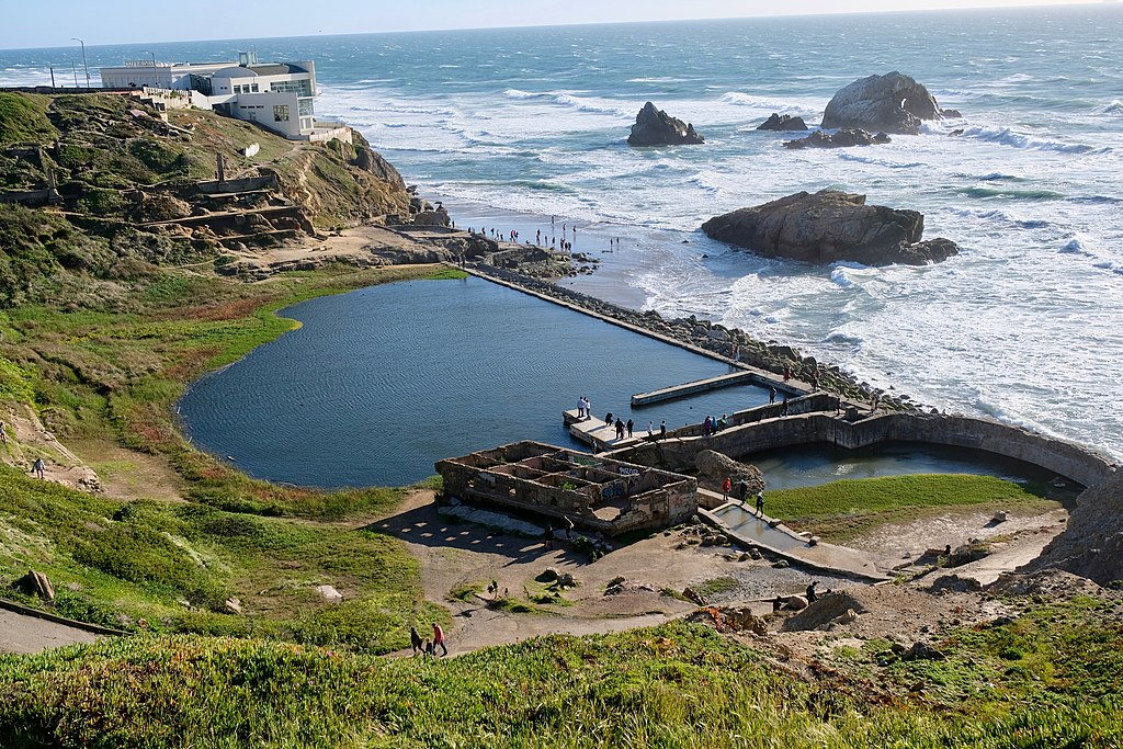
Sutro Baths at Lands End overlooking the Pacific Ocean
Begin at California and 32nd (via bus #1). Walk north to the Coastal Trail trailhead. As you hike along the dirt trail amid the eucalyptuses and pines, stop to take in the gorgeous views.
Several trails leading off to the right end at vista points that allow you to look back on the entrance to the bay, the Golden Gate Bridge spanning its narrow opening, and the Marin Headlands across the way. Continue along the trail, descending to the right when you come to a fork.
The trail ends at a parking lot. Head to its western edge to enjoy the unobstructed ocean views and to observe the ruins of the Sutro Baths. Built by Mayor Adolph Sutro and opened in 1896, the baths consisted of several pools housed within a massive structure made of iron and stained glass. The extraordinary creation eventually lost popularity, and it burned down in a fire in 1967. The concrete pools are all that remain today.
Head back the way you came. Take the wide paved road heading uphill on your right, looping around to the left of the Lincoln Park Golf Course to reach the Palace of the Legion of Honor. This fine-arts museum, specializing in European art and best known for its impressive collection of Rodin sculptures, was built by Alma de Bretteville Spreckels to replicate its eponymous French counterpart and completed in 1924.
Enter the Court of Honor to admire Rodin’s Thinker. After your visit, take El Camino del Mar to return to where you started, stopping at the arresting Holocaust Memorial on the parking lot’s western edge before heading down the hill and turning right on 32nd.
The Golden Gate Bridge to Baker Beach
This trail offers splendid ocean views and passes several artillery batteries, harking back to when the Presidio was not just a playground for locals but also a military base protecting the entrance to the bay. The walk ends at one of San Francisco’s most scenic beaches.
DIFFICULTY: Steep (though mostly downhill)
Begin at the Golden Gate Bridge vista point (via bus #28 or 29).
Walk over to the flagpole, then down to the paved bike trail that loops under the bridge (watch for cyclists here). Just as you begin to ascend on the far side of the bridge, take the dirt footpath leading off to the right. This puts you on the Coastal Trail, which hugs the shoreline all the way to Baker Beach.
You’ll first come upon Battery Boutelle, dating to 1900, then a parking lot; the trail continues straight across the road. Go through the forested area and continue alongside Lincoln. Note the World War II Memorial across the street on your left. Just beyond it, a narrow trail marked by a fence leads steeply down toward the water. This leads to Battery Crosby. Return to the main trail.
You’ll soon come upon another trail with a sign to Baker Beach. This is a steep and sandy descent, but there is a cable to help you. Battery Chamberlin hosts a gun demonstration the first and third Saturdays and Sundays of each month and houses a small exhibit focusing on the coastal defenses of the city.
Just beyond it is Baker Beach; its picturesque location and relative protection from ocean breezes makes it a popular destination.
Cliffs rise to the west, where the mansions of the affluent Seaclifl neighborhood perch on the ocean’s edge. The Golden Gate Bridge soars to the right, and the Marin Headlands loom ahead.
This mile-long beach is great for walking, but it is not suitable for swimming. Note that the northern end is a nude beach, Walk up the street from the main parking lot to catch bus #29.
Fort Mason
Designated a National Historic Landmark in 1985, Fort Mason has been converted into a thriving waterfront cultural center:
DIFFICULTY: Moderate
Begin at Marina and Buchanan (via bus #28). Originally built as a military compound more than 200 years ago, Fort Mason was headquarters for the San Francisco Port of Embarkation, which sent troops and cargo to the Pacific Theater of War during World War II.
Enter the main gate west of Buchanan beyond the parking lot, and head toward the waterfront warehouses. Building A houses the SFMOMA Artists Gallery. Greens, a long-standing vegetarian restaurant operated by the San Francisco Zen Center, boasts unparalleled views from its floor-to-ceiling windows, and a deli stocked with picnic fare.
Ascend the steps behind Building E. Loop counterclockwise along the pink paved path around the Great Meadow, stopping to pay homage to the statue of Phillip Burton (the congressman responsible for protecting 74,000 acres of city and North Bay land from development).
After completing the loop, head northeast on the main road, veering up and to the right to view the well-hidden Black Point Battery, originally a Spanish cannon emplacement dating to 1797 and later a Civil War fortification set into a bluff overlooking the bay; an original 1860s cannon is still in place. Retrace your steps to the main road and continue toward the Municipal Pier, where anglers and seagulls pluck fish from the bay. Catch bus #19 on Polk.
Telegraph Hill
Coit Tower, perched atop Telegraph Hill, is one of San Francisco’s most recognizable landmarks, and the neighborhood that clings to the hillside is a world unto itself.
DIFFICULTY: Steep
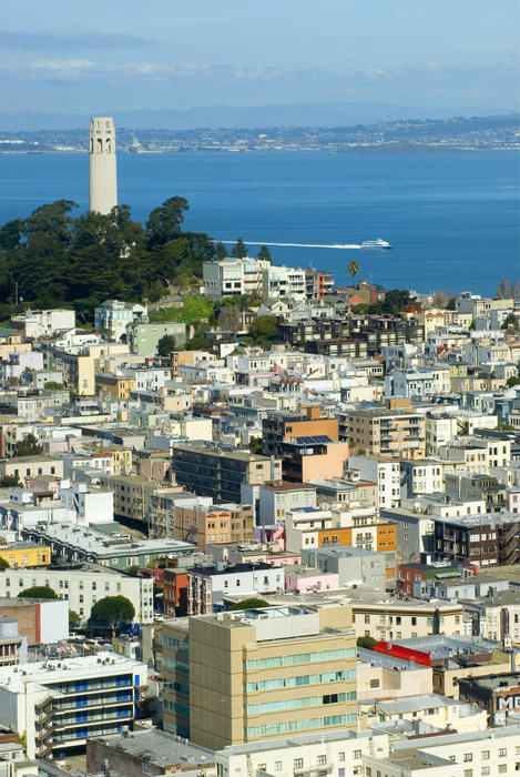
Coit tower on telegraph hill, san francisco
Begin at Francisco and Stockton (via bus #15) and head up the hill half a block, turning left onto Pfeiffer, a quiet residential street. Turn right on Grant and left on Greenwich, and head up the steps toward Coit Tower, built to honor the city’s firefighters; the surrounding park is dedicated to the memory of California’s pioneers. The 180-foot tower, completed in 1934, not only offers magnificent views from the top but also houses murals of local Depression-era scenes.
After savoring the glorious views (loop around the tower’s base to reach the vista point overlooking San Francisco to the south-or plan ahead and have a picnic on the grassy knoll there), head down the street east of the tower, looping left onto Filbert, which leads to the Filbert Street Steps. You will find yourself on a magically lush, green, and quiet hillside, flanked by homes hugging the steep slope. It is difficult to believe that this cluster of tree houses can exist in the heart of such an urban area.
If you’re lucky, you’ll hear (or see) the flock of wild parrots that inhabit the trees here. Descend the stairs, and emerge into the real world at Levi Plaza. Cross through the plaza, turn left on Battery to reach the Embarcadero.
Cross the street and head over to the Pier 23 Cafe (at Pier 23), an inviting waterfront restaurant in a small white building tucked between enormous piers. It offers one of San Francisco’s few casual waterfront-dining experiences, with good value and ambiance. Walk off your meal with a waterfront stroll, then catch one of the historic streetcars that rumble along the Embarcadero.
Fort Funston
This oceanfront park- -notable for its views, natural landscape, historic military installations, hang gliding, and popularity with local dog owners–attracts all types. Although it is difficult to reach the park via public transit, once here, you’ll feel as if you’ve left the city of San Francisco far behind.
DIFFICULTY: Moderate (mostly flat, with one steep hill up from the beach)
Begin at the parking lot at the top of the park (exit off Skyline; the closest buses are #19 and 88). This extraordinary park has several claims to fame. It is a premier dog-walking park, a historic site scattered with the ruins of various artillery batteries, an oceanfront area with gorgeous bluffs, beach access, and some of the only remaining sand dunes within city limits, and a popular launching point for hang gliders.
Begin by heading out to the observation platform along the wooden boardwalk west of the parking lot. You’ll be rewarded with outstanding views of the Pacific, dramatic cliffs to the south, Ocean Beach, two former military batteries tucked into the hillside, and, if the wind is right, a fantastic air show as hang gliders take off and soar above.
Return to the parking lot and descend the sandy coastal trail to the south of the boardwalk to the beach. Stroll south along the beach, taking in the sea breeze, the dogs romping in the surf, and the gradually crumbling cliff formations.
Retrace your steps and clamber your way back up. Then take the loop trail that begins north of the parking lot. Head along the paved trail, then take the sandy left fork that hugs the coastline, savoring the views and noting the massive gun batteries built between the two world wars.
On clear days, you’ll see Point Reyes to the north and the Farallon Islands to the west. When you come to the end, head under the battery to connect with the paved Sunset Trail, and turn right to return to the parking lot.
Bernal Heights
This neighborhood retains a cozy village-like atmosphere. A lovely hillside park with glorious views and easy access to San Francisco’s oldest farmers’ market make this a diverting outing.
DIFFICULTY: Moderate
Begin at Cortland and Bocana (via bus #24). This is a neighborhood in transition: In the late 1800s it was a land of dairy ranches run by Irish immigrants. It was later inhabited by many working in the naval shipyards during World War II and is now a gentrifying neighborhood full of young families.
Then head up Ellsworth to Bernal Heights Park, a grassy hilltop knoll with magnificent views from its 500-foot peak. Several trails loop around the park at different heights; some are quite precipitous, but there’s no way to get lost. The eastern end is less steep, and the lower trails are wider than the narrow paths around the radio tower at the top.
After enjoying the views, the greenery, and the fresh (often windy) air, return to Cortland. Food buffs should visit the Alemany Farmers’ Market (operating on Saturdays from 6 A.M. to 5 P.M. since 1947). To reach it, continue east down Cortland, turn right on Putnam, and take it over the hill. Less fancy than its Ferry Plaza counterpart, it caters to a more diverse crowd and has better prices. Return to Cortland to catch bus #24.
Twin Peaks
This walk to the top of one of San Francisco’s highest hilltops offers unparalleled views of the Bay Area. It is often windy on top, so plan accordingly.
DIFFICULTY: Steep (includes staircases)
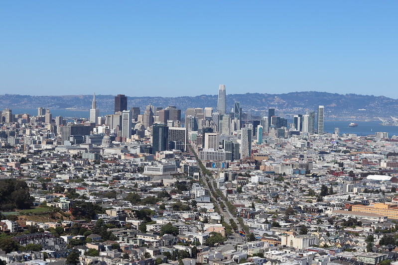
View of San Francisco from Twin Peaks
Begin at Clayton and Corbett (via bus #33). Walk up the Pemberton Stairway, savoring the greenery. Be sure to look back at the views of downtown as you climb. N
Turn right on Crown at the top of the stairs, left on Clarendon, then left onto Twin Peaks Boulevard. This fairly steep grade continues for three-quarters of a mile to the top. Distract yourself from the difficulty by enjoying the view that becomes increasingly dramatic as the city drops beneath you; on clear days Mt. Diablo, in the East Bay, is visible.
You’ll gradually leave the city behind and come upon a grassy hilltop. At the top, turn left toward the radio towers to reach the official vista point. You’ll be rewarded with outstanding views extending from the Pacific Ocean to the west to the Peninsula to the south, all encircling the city spread out below.
The layout of the city also becomes clear from this vantage point, with Market Street clearly bisecting the city and Golden Gate Park, the Panhandle, and the Presidio all visible.
If this vista isn’t enough, climb one or both peaks (this part of the walk requires climbing up wooden steps and navigating a rocky path). It’s worth it, however, for the exhilaration of standing atop the bald peaks 900 feet above sea level.
Return the way you came, catching the #33 bus at Clayton and Carmel. There’s nowhere to buy food up here (aside from a snack truck), so plan ahead if you want to stay for a picnic.
Walks with a View in San Francisco – Be Prepared!
With 43 hills within its city limits, San Francisco has breathtaking views, and a distinctive skyline. However, the hills also create a cityscape that requires some more forethought. Sensible shoes are always smart when you plan to do a lot of walking, but nowhere is that more true than in the city by the Bay.
One last thing: San Francisco weather is notoriously unpredictable. Although it is rarely very cold, the city is not always basking in California sunshine, and it is often quite breezy. The hills also create distinct microclimates: It can be foggy in one part of town and sunny just one hill over. San Francisco is often cloaked in its trademark fog on summer mornings and evenings, while winter boasts many days of glorious sunshine. Plan accordingly, and always bring along an extra layer.