Uganda is filled with mind-blowing natural and man-made historical sites and wonders that tell stories of creation, civilization, how our ancestors lived, and how they did things. These sites take us back into history as we try to reclaim our origins and who we are.
They teach us stories that maybe would have faded away into the thin air of human forgetfulness if not for their presence and daily reminders. Going across Uganda, there is a number of such historical sites and monuments that tell a part of their share of humanity. This list contains just some of the most famous and most recommended historical places in Uganda.
Independence Monument
This historical site in Uganda is a symbol of independence. The Monument depicts a woman unwrapping her child and raising it to the skies, which signified that the British had done their part and it was now up to Uganda, the new child, to do the rest.
Kabaka’s Palace
This historical place in Uganda is where the King of Buganda lived and ruled his subjects as the Kingdom was a centre of all Uganda’s early politics. It is where Agreements like putting Uganda under British protectorate, the 1900 Buganda Agreement, and the 1962 Independence Agreement were signed from. It is also a place where thousands of Ugandans lost their lives during Idi Amin’s and Obotte II’s reigns in the Torture Chambers constructed by Idi Amin on the palace grounds.
Namugongo Martyrs Shrine
Uganda Martyrs Museum Namugongo
Located in Wakiso district, the Namugongo Martyrs shrine was built in honour of the men who were tortured and burnt to death for refusing to renounce the newly found religions in 1886 by the then King Mwanga II of Buganda. Each year, thousands of Christians congregate to commemorate the lives and strong faith of the martyrs on 3rd June at the Shrine premises.
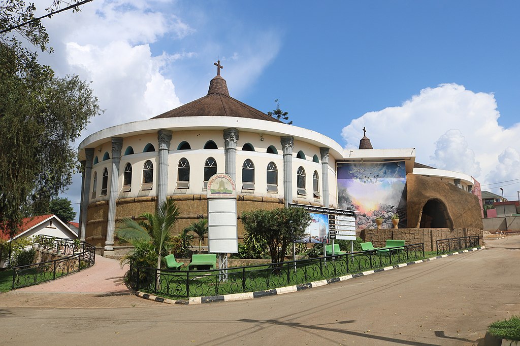
Gadaffi Mosque
This mosque goes back in history, construction began during Idi Amin’s reign and was put to a halt after his overthrow. It was completed two decades later after a donation from Muammar Gaddafi, the then-president of Libya to become the home of the Uganda Muslim Supreme Council. It is best known for its admirable interior decor and sweeping views of Kampala city after a climb of the main minaret’s swirling staircase of 300 steps.
Nyero Rock Paintings
These are tiered rock shelters with primitive paintings on their inner surfaces, located in the Kumi district, Eastern Uganda. The historical site in Uganda contains some of the most important and famous rock art in the entire country. They are believed to have been in existence before 1250 AD and were first documented in 1913 by researchers. The rock art is part of a homogenous tradition that is often depicted in red pigment and is spread across Africa, matching the distribution of the late Stone Age hunter-gatherer culture.
Kasubi Tombs
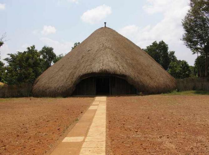
Entrance of the Kasubi Tombs
Grass-thatched domes and structures made of organic materials outline and set the Kasubi tombs apart from other historical sites in Uganda. They were constructed in 1882 and converted into a royal burial ground in 1884. It is a burial ground for four consecutive Buganda Kings and houses a museum of the Baganda civilization that dates back to the 13th century. The tomb is a symbol of the spiritual, political, and social state of the Baganda.
Namirembe Cathedral
On Namirembe hill in Kampala sits Namirembe Cathedral, a church known as the centre of Christianity and the headquarters of the Anglican faith in Uganda. A visit here gives one an understanding of how the Anglican church started, how many churches were built before the magnificent building that currently sits on the hill, and how the church became a powerful influence in Uganda’s politics during the colonial days.
Amabeere ga’ Ninamwiru Caves
This mythical site in Uganda includes stalactites and stalagmites shrouded in legend. It is said that following a prophecy that her daughter’s son would kill him for the throne, King Bukuku cut off his daughter’s breasts to deny her a chance at motherhood but she later did give birth and fed her son with the milky salty water that drips in these caves.
Bahai Temple
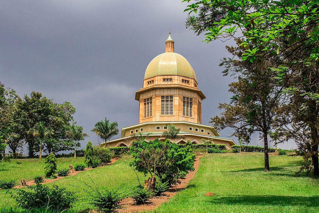
Bahai Temple of Uganda surrounded by rich green vegetation
This temple sits on Kikayi hill in Kampala and is the mother Temple of the Bahai faith in Africa which began to take root in Uganda in 1951. A visit to the temple offers visitors wonderful views of the interior and the beautiful gardens are great for contemplation and meditation.
Walumbe Tanda Pits
Luganda legend has it that Walumbe (evil) accompanied his sister Nambi and her husband Kintu to earth and is said to be the cause of suffering and death. When his brother, Kaikuzi came to pick him up and take him back to heaven, he hid in the Tanda pits. This site contains over 240 pits and two shines and has spears, shields, calabashes as well as fireplaces named after different Buganda gods.
Speke Monument- Source of the Nile
This historical monument in Uganda is situated on the western Bank of the River Nile in Njeru and was set up in remembrance of John Hanning Speke an Explorer and Adventurer who was the first white man to discover the source of the Nile. It is similar to the one located near the Junction of Lancaster walk and Budges walk in Kensington Gardens, one of London’s Royal Parks. Made from red granite, the monument was designed by Philip Hardwick.
The Uganda Railway
Construction of this iconic structure started in 1896 and was completed in 1926. It opened up Uganda to trade with other countries and also was a major form of transport back in the day. Also, the first bridge to be built across the Nile happened to be the first railway line. The history of the Uganda railway is marked by a Railway Museum in Jinja and the Uganda Railways building is one of the oldest buildings in Uganda.
These are only a glimpse into the multiple mystical, archaeological, religious, and historical sites in Uganda. There is more to it than just these in all regions of the country. Read more about travel and backpacking advice for Uganda before you visit, or enjoy our tips for traveling Uganda on a budget.